OUTDOOR CYCLING SERIES - Causses du Quercy 2027
- Next event : Mid-May 2027
- Last event : 15 Fri ➜ May 17, 2026
The event in a few words
Have you ever seen an elevation profile that looks like an adrenaline-induced ECG? 📈No? Well, prepare your heart because it's going to be put to the test during the Outdoor Cycling Series - Causses du Quercy! 🫀
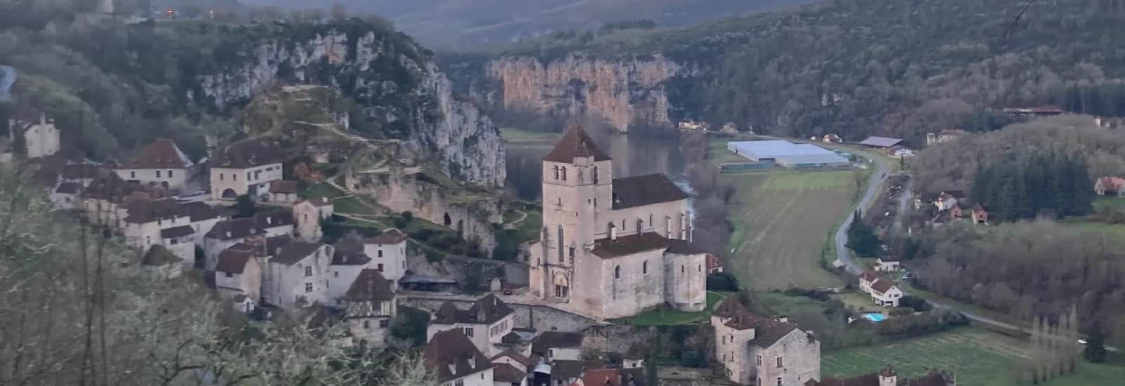
Prepare your gravel or your road bike for mid-May, then head to Cahors, in the Lot, to explore one of the most rugged, beautiful, and geologically wild territories in France (recognized as an UNESCO Global Geopark in 2017 🌍, mind you! 🧑🏫): the Causses du Quercy. There, it's the heart of Occitania and the southwest: it's beautiful, it's a good place to live, and you'll be cycling through a nature that demands to be observed (even if you're in rocket mode)! 🚴
Two distances are scheduled: the 350 km / 6,000 D+ course starting on Friday for those not afraid of the dark 🌙, and the 150 km / 2,800 D+ course on Saturday for those still wanting to get home standing 🧍. And you have the choice between your gravel or your road bike. A piece of advice, take the one you usually use, otherwise, the hours will be LONG, and your calves will be at the end of the line 🦵. The start and finish are at Cahors, a city worth stopping by for a moment before or after cycling 🏛️ (depending on your schedule 📔). Gallo-Roman, medieval, financially formidable in the Middle Ages, it has a typical charm of the region that will show you all kinds of colors, in every sense of the word 😁. The city even retains a funny memory of its lively past: the Pont Valentré, begun in 1308, took 70 years to complete ⏳, according to legend because the desperate architect made a pact with the devil to finish the job, only to trick him by asking to bring water with a perforated sieve 😈. Satan, vexed, returns every night to loosen a stone from the central tower, preventing the bridge from being completed. The mischievous little devil sculpted at the top is still there and will watch you as you pass. Even the architecture trolled the devil, so you can say you are in good hands 🙌.
The Causses du Quercy is where geology decided not to do things by halves 🪨. Millions of years of limestone dissolution have sculpted a rather atypical territory: flat and dry plateaus that resemble Inner Mongolia, valleys without rivers carved by watercourses that have entirely disappeared today, cliffs that appear out of nowhere 🧗, forests that nestle between the stones as if they were always there 🌲... On the road course, you can observe small rolling country roads, fields, and viewpoints to make you forget the pain 🤩. On the gravel course, you'll have access to forest tracks, rugged single tracks, plateaus, and plains that follow one another in an organized disorder that ensures you never know what's coming at the next turn 🚵. The 350 km course draws a large loop to the north: you will pass by Rocamadour, brush past the gouffre de Padirac, not forgetting Figeac, St-Cirq-Lapopie (rated the most beautiful village in France so open your eyes 👀), and the Grotte de Pech Merle. The altitude profile says it all without hesitation: constant oscillations between 60 and 540 meters, with no respite, featuring regular peaks throughout the length 📊. The kind of profile that makes you say "it didn't climb that much" km after km, and catches up with you at km 100 when you have nothing left in your legs 🙃.
Don't worry though, the Quercy nourishes as well as it exhausts 😋. The wine of Cahors, a Malbec so dark it's called the "Black Wine", was the favorite brew of Russian tsars in the 18th century 🍷. The black truffle grows on the same limestone plateaus you just taxed, delicious in an omelet or on buttered bread, it is as deserved as it is savored 🖤. The Quercy lamb with Red Label is recognizable by its natural black glasses 🐑 (like Michael Jackson), and the Rocamadour cheese, this little goat cheese that shepherds produced as early as the 15th century to pay their tithes, is still enjoyed warm on morning markets 🧀. 350 km or 150 km on the wheels 🛞, a plate of truffle before you and a breathtaking viewpoint, that's what we call a perfect loop 🔄.
So go for it, because if there's one place that stands out 😉, it's the Quercy! 😍
4 reasons to join this race
A distance for every taste
350 kmTOP
150 km
- Mid-May 2027
- Elevation gain : 6000mD+
350 Km Gravel
Gravel Bike- Mid-May 2027
- Elevation gain : 6000mD+
150 Km Route
Road Cycling- Mid-May 2027
- Elevation gain : 2800mD+
150 Km Gravel
Gravel Bike- Mid-May 2027
- Elevation gain : 2800mD+
Frequently asked questions (FAQ)
You will receive a Road Book by email about 15 days before the start. This document will detail the exact location and schedule for participant check-in and the handover of tracking equipment.
Departures will take place from Cahors on the following dates and times:
350 km course: Friday, May 15, 2026, at 8 a.m.
150 km course: Saturday, May 16, 2026, at 8 a.m.
No, it is not mandatory, however, you will need to present a PPS certificate dated less than one year from the race date.
Yes, you must be 18 years old on the race dates to participate.
85€ for the 150 km*
125€ for the 350 km*
*Platform management fees will be added at the time of payment.
The maximum finish time for all courses is set for Sunday, May 17, 2026, at 12 p.m. in Cahors. You must manage your progress to meet this event end deadline.
The event is entirely self-supported. You will need to manage your own provisioning throughout the course. The organization only provides friendly refreshment at the finish (solid, liquid, sweet, and salty) to encourage interaction among participants.
You must have a bike suitable for your chosen discipline (Road, Gravel, or MTB) with gear appropriate for significant elevation. Wearing a helmet is mandatory. The organization will provide a tracker for live tracking and safety. The use of e-bikes is prohibited. You will also need to have a device for reading the GPX file of the route, which will be sent to you 3 days before the start.
Your registration includes:
Event Road Book with the latest technical and detailed info (exact location and times...) sent about 15 days before the start
Access to WhatsApp group/instant messaging for the latest useful and important info
Sending of the GPX file of the course 3 days before the start
Tracker provided with battery life/tracking for the adventure time
Public platform live tracking access (organization safety + participants' personal network)
Welcome packs for everyone
Technical briefing before the start
Finisher and souvenir packs for everyone
Arrival refreshment solid/liquid/sweet/salty, friendly and warm for an exchange time between road adventurers
Overall logistical and technical organization
A unique route where every centimeter was judiciously chosen on the map (not automatically traced) and every meter was reconnoitered on the ground
An extraordinary and unforgettable sporting and human adventure in the wild, full of discovery and sharing!
Focus


A next-gen platform helping sports enthusiasts of all levels discover territories and heritage through races tailored to them.
Made in France, between Lyon and Nantes