
Monterosa East Himalayan Trail 2026
- Next event : 1 Sat ➜ August 2, 2026Date confirmed
- Last event : Sat, August 2, 2025
The event in a few words
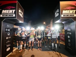
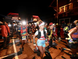
5:00 AM. Headlamp on 🔦. The Anzasca Valley is still asleep 😴, and you are already there, staring into the dark at a wall of ice and rock that touches the clouds ⛅️. Welcome to the Monterosa East Himalayan Trail 🏔️.
Does the name sound big? It is. The east face of Monte Rose, 4,634 m, the first summit of Switzerland 🇨🇭 is the only wall in the entire Alpine arc that climbers compare, without exaggeration, to the great Himalayan faces. Generations of climbers 🧗 from around the world have left their marks here. And in August, it's you who will run at its foot for the trail of a lifetime. The MEHT starts from Macugnaga, a Walser village perched at 1,327 m of altitude in the north of Piedmont in Italy 🇮🇹. Four distances are offered, the "EPIC 58K", the "SKY 39K", the "SCENIC 21K" and the "ZMAKANA' 13K" along with a Mini Trail of 2 km for children on Sunday morning 🎉. Something to bring the whole family into the adventure 🧑🧑🧒🧒. One figure sets the scene: the highest point of the "EPIC 58K", the Passo Mondelli, rises to 2,886 m.
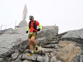
Say goodbye to wide, paved avenues of urban marathons ❌. Here, the terrain is made up of real mountains ✅. Trails, pastures, rocky passages, moraines, and that alpine sky that can change from cobalt blue to black clouds in twenty minutes flat ⏱️. The organizers state clearly: every participant must be self-sufficient in extreme conditions: cold 🥶, heat 🥵, rain 🌧️, wind 💨, snow ❄️. In August at high altitude, anything can happen: the mountain makes no concessions 😬. All races start and finish in Macugnaga, where the MEHT Village 🏘️ is located. The routes dive into the heart of the valley, crossing charming hamlets, Pestarena, Isella, Fornarelli, before climbing and, for the two longest distances, reaching the Passo Mondelli at 2,886 m. This pass marks the Italian-Swiss border with the Valais canton 🇨🇭. In other words, on the "EPIC" and "SKY", you cross from one country to another while running 🏃. Not many trails can boast that 🤔. And then there's Mont Rose itself 🏔️. Running al cospetto of the highest face of the Alps, this Italian phrase meaning "in the presence of", almost "under the watchful eye of", resets the scoreboard. Runners say the sunrise over the east face 🌄, after the first hours of running in the dark, is one of the most memorable moments of their sporting life. No marketing pitch behind it. Just rock 🪨, ice 🧊, lakes and you 🫵.
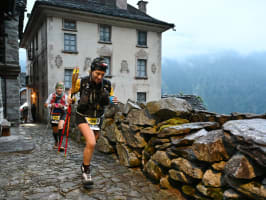
Macugnaga is not just a trail decor in the middle of nature. It's a living village with 800 years of history behind it 🏡, founded in the 13th century by the Walser, a people of Germanic origin who crossed the Passo del Monte Moro from the Swiss Valais to settle in this remote valley. Their language, Titsch, a Germanic dialect still spoken by a few elders, their larch wood architecture, their agricultural traditions: none of this has evaporated with mass tourism. The Dorf, the historic village core, will charm you with its typical houses. As well as the Old Church from the 14th century ⛪️, with its old lime tree, it has a certain solemnity 🌳 and we sincerely recommend you have a look 👀.
After the physical effort 😮💨, the Lago delle Fate (Lake of the Fairies) in the Quarazza valley offers a visual reward worthy of its name 🧚. And if you want to go even higher without the strain, the Macugnaga cable car will take you up to 3,000 m at Passo del Monte Moro, exactly where the "EPIC" runners pass in sweat. Guaranteed view of the Swiss side of Monte Rosa, with the Matterhorn visible in clear weather as a bonus. On the culinary side, the region offers some of its best arguments 🍽️. The alpine cheeses ripened at altitude are the pride of the valley, with a pronounced character that lowland cheeses can't imitate 🧀. The Walser rye bread, dense and aromatic, has been part of local culinary heritage for centuries 🍞. The region's holy grail is the Bettelmatt 😍: a very rare alpine cheese, produced only on a few pastures above 2,000 m in the neighboring valleys of Formazza and Antigorio, mentioned in medieval documents from the 15th century for its exceptional quality 👌. If you find it, don't let it slip away! 😉
Maybe you'll see la vie en rose after running this trail 🎀.
4 reasons to join this race
A distance for every taste
58 kmTOP
39 km
21 km
13 km
2 km
- Saturday, August 1, 2026 at 5:00 AM
- Elevation gain : 4100mD+
- 58 km
- 3 ITRA points
A few more words
The EPIX 58K is the main event of the Monterosa Est Himalayan Trail with 4,100 mD+ 😮💨. You will start from Macugnaga 🏘️ and follow the Torrente Anza 💦. Your first major ascent will begin at km 6: the Paso Mondelli which peaks at 2839 m. 10 km of steep slope between forest trails 🌳 and rocky paths 🪨 that will surely remind you that a trail in the mountains is no walk in the park 😅. From km 20 to km 27, you will enjoy a stop by the Mattmark Dam and its lake. You will then undertake the major ascent towards the Passo Monte Moro at 2,985 m altitude 📈, a peak offering a panoramic view of the Swiss summits 🇨🇭. The descent will take you along the glacial moraines of the Belvedere and Locce Lake, close to the seracs. You will finish by paths linking the traditional hamlets before crossing the finish line 🏁.

Trail 39 km
Trail- Saturday, August 1, 2026 at 7:00 AM
- Elevation gain : 2700mD+
- 39 km
- 2 ITRA points
A few more words
You will begin your "SKY 39K" journey along the Torrente Anza 💦 up to km 6 before diving into the forest trails. They will take you to the Passo Mondelli at km 15 at 2839 m. You will stay at altitude for the next 15 km where you will tread along the edges of the Mattmark dam and its lake 🛶. The route will rise again to pass the Passo Moro before descending towards the Alpe Bill at km 35. The path is less technical than the long format but remains demanding due to its relentless restarts. You will pass through strategic viewpoints allowing you to admire the glaciers from above. You will have 4 km left before crossing the finish line 🏁 and enjoying the view, but from below this time 😉.

Trail 21 km
Trail- Saturday, August 1, 2026 at 9:00 AM
- Elevation gain : 1400mD+
- 21 km
- 1 point ITRA
A few more words
The "Scenic 21K" is 21 km with 1,400 mD+ that prioritizes the panoramic balconies of the Anzasca Valley 😎. You will follow historic paths once used by miners and Walser shepherds. The route rises towards Alpe Burki and the Belvédère, without reaching high-altitude areas. You will pass through centuries-old larch forests and altitude meadows 🌾. The track is less technical than the longer formats but remains challenging due to its relentless restarts. You will pass by strategic viewpoints allowing you to admire the glaciers above you 🧊. The finish is through Lago delle Fate 🛶 and the village of Fornarelli 🏘️ before returning to your starting point at Macugnaga 🏁. You will have well deserved a rest after crossing the finish arch 😅.

Trail 13 km
Trail- Saturday, August 1, 2026 at 10:00 AM
- Elevation gain : 700mD+
- 13 km
A few more words
Ready for 672 m D+ and 13 km of trail in the fresh air of the mountain? ⛰️ Your route will start in Macugnaga in Italy. You'll pass through Pacetto before heading back along Macugnaga 🏘️ on the south bank of the Torrente Anza 💦. You'll delve into forest paths, where the incline will be felt, passing through Bord (km 5) Schilt (km 6) before reaching Lago Delle Fate 🛶 and the valley of Quarazza (km 8). The last few km will take you back to your starting point via Fornarelli, Isella, and Ronco to cross the finish line 🏁.

2 km : MEHT Mini Trail 2K
TrailFrequently asked questions (FAQ)
You will collect your race bib at the MEHT Village located in Macugnaga. Collections will take place:
on Friday, July 31, 2026, between 10 AM and 8 PM
on Saturday, August 1, 2026, between 4 AM and 9:45 AM
The starts will take place from the village of Macugnaga on Saturday, August 1, 2026, according to the following schedule:
5 AM: EPIC 58K.
7 AM: SKY 39K.
9 AM: SCENIC 21K.
10 AM: ZAMAKANÀ 13K.
Yes, you are required to provide a medical certificate for fitness to compete in athletics, valid on the date of the race. This rule applies to all distances, except for the 13K format and the children's race.
You must be at least 18 years old by August 1, 2026, to register for the 58K, 39K, 21K, and 13K distances. A non-competitive 2 km event is open to younger participants on Sunday, August 2, 2026.
Prices vary according to the chosen distance and registration date:
EPIC 58K: from €70 to €100.
SKY 39K: from €50 to €80.
SCENIC 21K: from €30 to €60.
ZAMAKANÀ 13K: from €20 to €50.
Time limits are in place to ensure your safety.
For the EPIC 58K, the maximum time to complete the event is 18 hours.
For the SKY 39K, you will have 12 hours and 30 minutes to cross the finish line.
For the SCENIC 21K, you will have 7 hours and 30 minutes.
For the ZMAKANA 13K, you will have 5 hours.
Specific details of intermediate checkpoints will be communicated during the technical briefing.
The organization will set up solid and liquid refreshment stations along the courses. You will find the following checkpoints:
EPIC 58K: 7 refreshment stations located at Alpe Meccia, Alpe Bill, Alpe Sonobier, Passo Monte Moro, Alpe Fillar, Belvedere, and Zamboni Zappa.
SKY 39K: 4 refreshment stations located at Alpe Sonobier, Passo Monte Moro, Belvedere, and Zamboni Zappa.
SCENIC 21K: 2 refreshment stations located at Alpe Meccia and Alpe Bill.
ZAMAKANÀ 13K: 1 refreshment station located at Pecetto.
The following equipment is required for the high mountain events:
Minimum 1L water supply.
Survival blanket.
Whistle.
Waterproof jacket with hood.
Mobile phone with charged battery.
Personal cup.
Headlamp (for early morning starts).
If you have any questions, you can contact the organizers by email: meht@evodata.it
You can check the race rules here
Focus


A next-gen platform helping sports enthusiasts of all levels discover territories and heritage through races tailored to them.
Made in France, between Lyon and Nantes